Fragment
ca. 1588 (made)
| Artist/Maker | |
| Place of origin |
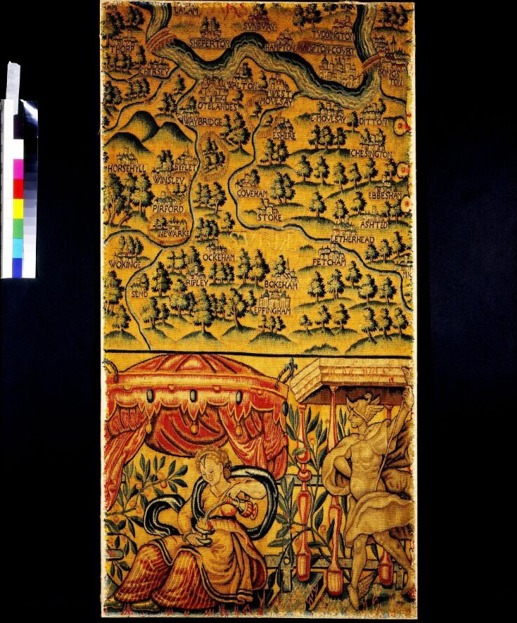
Maps used as designs for tapestry wall hangings are uncommon. Only three other 16th century examples are known; a map of Paris woven around 1540 and one of Leiden in 1584. A set of twelve showing the progress of the Armada up the English Channel in 1588 was commissioned by Charles Howard, Lord Admiral of England at the time, from workshops in Delft in 1596. Only that of Leiden survives, in the Lakenhal in Leiden.
Ralph Sheldon’s four tapestry maps of English counties were probably ordered for the new house he completed at Weston near Long Compton, Warwickshire around 1590. Focussed on the counties of Oxfordshire with Berkshire, Warwickshire, Worcestershire and Gloucestershire, the set’s total length of 21 metres depicted a view across England from London to the Bristol Channel. This splendid panorama, 4 metres high, reflected not only Ralph’s known interest in maps but also the excitement created by the first maps of English counties published by Christopher Saxton as an Atlas in 1579.
To bring those maps alive the tapestry designer replaced symbols with pictures and added or emphasized details. The gates and palings of parkland stand out; clusters of houses represented villages; windmills, beacons and bridges close to Sheldon properties were added. Towns and some of the large houses, including Sheldon’s own and those of his relatives, were depicted as they really looked. Hills and rivers portrayed the landscape across which wandered roads, which Saxton had not included. Only trees were drawn out of scale, often shown taller than the church towers and spires.
The original design, the same for every tapestry, is made clear by the only intact survival, hanging in the Warwickshire Museum, Warwick. In the lower right-hand corner were the Sheldon family arms; above was text based on William Camden’s best-selling description of Britain, the Britannia. The corners of the left-hand side showed the royal arms and a scale and dividers. A variety of designs borrowed from printed sources made up the borders, including flowers, canopies, columns and the figures of Hercules, Temperance and Mercury. A map of Africa was inserted into the lower border. Doggerel verses described the county and the orientation appeared in each border.
Ownership and Use
The four tapestries, which probably took several years to produce, created a unique decorative scheme, amongst the finest of the time. They may have been damaged when parliamentary forces attacked the royalist Sheldons’ house in the Civil War (1642-48). Much later, these pieces were deliberately cut from the lower right-hand corner to decorate a fire screen.
Object details
| Categories | |
| Object type | |
| Materials and techniques | Tapestry-woven in wool and silk |
| Brief description | Tapestry fragment woven in wool and silk, Sheldon Tapestry Workshops, possibly made in Warwickshire, ca. 1588 |
| Physical description | Tapestry fragment woven in wool and silk. 16-17 warp threads per in (6-7 per cm). Part of the lower edge of the tapestry map of Oxfordshire and Berkshire, and showing a portion of Surrey and a short stretch of the River Thames. Part of the border of the map is visible with a female figure seated beneath a canopy and pouring water from an ewer into a goblet. |
| Dimensions |
|
| Gallery label | British Galleries:
One specialty of the Sheldon workshops was their large tapestry maps. These were informative and colourful hangings showing place names and important landscape features. They often included the initials or arms of the maker or owner. This fragment comes from a tapestry bearing the name of Ralph Sheldon Senior (1537-1613). It shows parts of the counties of Surrey and Middlesex with the River Thames near the top.(27/03/2003) |
| Credit line | Given by Mrs McKnight Franchot |
| Object history | Bought by Horace Walpole in 1781 for Strawberry Hill. |
| Summary | Maps used as designs for tapestry wall hangings are uncommon. Only three other 16th century examples are known; a map of Paris woven around 1540 and one of Leiden in 1584. A set of twelve showing the progress of the Armada up the English Channel in 1588 was commissioned by Charles Howard, Lord Admiral of England at the time, from workshops in Delft in 1596. Only that of Leiden survives, in the Lakenhal in Leiden. Ralph Sheldon’s four tapestry maps of English counties were probably ordered for the new house he completed at Weston near Long Compton, Warwickshire around 1590. Focussed on the counties of Oxfordshire with Berkshire, Warwickshire, Worcestershire and Gloucestershire, the set’s total length of 21 metres depicted a view across England from London to the Bristol Channel. This splendid panorama, 4 metres high, reflected not only Ralph’s known interest in maps but also the excitement created by the first maps of English counties published by Christopher Saxton as an Atlas in 1579. To bring those maps alive the tapestry designer replaced symbols with pictures and added or emphasized details. The gates and palings of parkland stand out; clusters of houses represented villages; windmills, beacons and bridges close to Sheldon properties were added. Towns and some of the large houses, including Sheldon’s own and those of his relatives, were depicted as they really looked. Hills and rivers portrayed the landscape across which wandered roads, which Saxton had not included. Only trees were drawn out of scale, often shown taller than the church towers and spires. The original design, the same for every tapestry, is made clear by the only intact survival, hanging in the Warwickshire Museum, Warwick. In the lower right-hand corner were the Sheldon family arms; above was text based on William Camden’s best-selling description of Britain, the Britannia. The corners of the left-hand side showed the royal arms and a scale and dividers. A variety of designs borrowed from printed sources made up the borders, including flowers, canopies, columns and the figures of Hercules, Temperance and Mercury. A map of Africa was inserted into the lower border. Doggerel verses described the county and the orientation appeared in each border. Ownership and Use The four tapestries, which probably took several years to produce, created a unique decorative scheme, amongst the finest of the time. They may have been damaged when parliamentary forces attacked the royalist Sheldons’ house in the Civil War (1642-48). Much later, these pieces were deliberately cut from the lower right-hand corner to decorate a fire screen. |
| Associated object | |
| Collection | |
| Accession number | T.61-1954 |
About this object record
Explore the Collections contains over a million catalogue records, and over half a million images. It is a working database that includes information compiled over the life of the museum. Some of our records may contain offensive and discriminatory language, or reflect outdated ideas, practice and analysis. We are committed to addressing these issues, and to review and update our records accordingly.
You can write to us to suggest improvements to the record.
Suggest feedback
You can write to us to suggest improvements to the record.
Suggest feedback
| Record created | March 27, 2003 |
| Record URL |
Download as: JSONIIIF Manifest
