
Royal Geographical Amusement or the Safe and Expeditious Traveller Through all the Parts of Europe by Sea and by Land
Board Game
01/12/1823 (published)
01/12/1823 (published)
| Artist/Maker | |
| Place of origin |
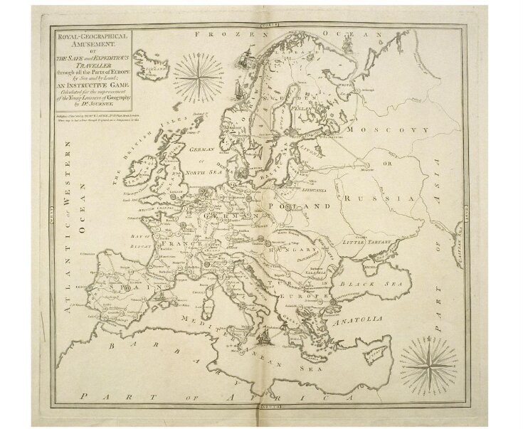
This European-centred game was originally a companion to 'A New Royal Geographical Pastime for England and Wales' and is subtitled an 'Instructive Game Calculated for the Improvement of the Young Learner of Geography by Dr Journey'.
It was originally published by Robert Sayer in 1774. Laurie and Whittle succeeded Sayer in 1794 and were in turn succeeded by R H Laurie in 1813. It would appear that the game is an impression from the original plate with the lettering altered.
It was originally published by Robert Sayer in 1774. Laurie and Whittle succeeded Sayer in 1794 and were in turn succeeded by R H Laurie in 1813. It would appear that the game is an impression from the original plate with the lettering altered.
Object details
| Categories | |
| Object type | |
| Parts | This object consists of 2 parts.
|
| Title | Royal Geographical Amusement or the Safe and Expeditious Traveller Through all the Parts of Europe by Sea and by Land (manufacturer's title) |
| Materials and techniques | Engraved paper |
| Brief description | Engraved paper game, Royal Geographical Amusement, published in England by R H Laurie in 1823 |
| Physical description | Design: engraving; impression from the plate used for printing the playing sheet showing a map of Europe with the principal and capital cities numbered. together with printed sheet of rules and descriptive text. No. of squares: 103 Squares illustrated: ? Square numbering: 1 to 103 Squares titled: in text Subject of starting square: Calais Subject of ending square: London |
| Dimensions |
|
| Object history | The game was published by Robert Sayer in 1774. Robert Laurie and James Whittle succeeded Sayer at his premises in 1794 and were in turn succeeded by R H Laurie in 1813 (1813-59). It would appear that the game is an impression from the original with the lettering altered. See details after the rules. See also E.1747 & 1767-1954 The game was originally a companion to A New Royal Geographical Pastime for England and Wales. CGG-GAMES & PUZZLES, 1991 |
| Historical context | Rewards: forward movement and extra turns Forfeits: backward movement and missing turns No. of Players: 2 to 6 Equipment required: teetotum; turned pillars called Travellers with four counters matching each of the Travellers Rules: EXPLANATION AND RULES OF THE GAME The number of players may be from two to six; he who has the highest number in spinning the totum, is to begin, and the others are to follow according to their respective numbers. Three Gentlemen or Ladies are supplied to make the tour of Europe; they are represented by the three Turned Pillars, called Travellers, each of the players having one of these, which is to be placed at the stage corresponding to the number turned up. the four counters, of the same colour with the Traveller, are to be employed as Markers, and take the name SERVANTS. The player is to lay down as many of these as he is ordered to wait turns, and when it comes to his turn to spin again, instead of spinning he must take up one Marker, and so on, till they are all taken up. The person who plays first, places his Traveller according to the number given by the totum, for instance, if you turn up No. 7, you place the turned Pillar upon St. Malo, and there let it remain until it is you turn to spin again; f at the second spinning you turn up No. 4, let it be added to 7, which being 11, you proceed on your journey in removing the Traveller to Bordeaux, and so on till you arrive at London, No. 103, which is the end of the Game and the Journey. But as it may very often happen that the Traveller should be carried beyond this last number, by the chances of play, in such a case he is to return to Hanover at 89 and then spin again his turn, to take his departure from that town. The Traveller, which is overtaken by another, must go back to the stage left vacant by the former. The rules are followed by a descriptive passage for each of the 103 stages. This also gives any forfeits and rewards At the bottom of the rules and explanation is the following text: LONDON: Printed for Robert Sayer and Co., Fleet Street. Where may be had just published, A collection of new maps dissected for the instruction and amusement of youth, comprehending the world and the quarters, England, Scotland, Ireland and all the Empires, Kingdoms and States in Europe. Each enclosed in a very neat mahogany box. Price 7s. 6d. The same, with the sea coasts, etc, larger 10s 6d. each. Also a new Geographical Game of England and Wales; with an excursion to France, Scotland and Ireland, being a companion to this. Rules placement: printed sheet with descriptive text of each stop |
| Summary | This European-centred game was originally a companion to 'A New Royal Geographical Pastime for England and Wales' and is subtitled an 'Instructive Game Calculated for the Improvement of the Young Learner of Geography by Dr Journey'. It was originally published by Robert Sayer in 1774. Laurie and Whittle succeeded Sayer in 1794 and were in turn succeeded by R H Laurie in 1813. It would appear that the game is an impression from the original plate with the lettering altered. |
| Collection | |
| Accession number | E.1773&A-1954 |
About this object record
Explore the Collections contains over a million catalogue records, and over half a million images. It is a working database that includes information compiled over the life of the museum. Some of our records may contain offensive and discriminatory language, or reflect outdated ideas, practice and analysis. We are committed to addressing these issues, and to review and update our records accordingly.
You can write to us to suggest improvements to the record.
Suggest feedback
You can write to us to suggest improvements to the record.
Suggest feedback
| Record created | March 4, 2000 |
| Record URL |
Download as: JSONIIIF Manifest
