
Aegypyus Hodierna
Print
ca. 1719-1730 (made), circa 1900 (made)
ca. 1719-1730 (made), circa 1900 (made)
| Artist/Maker | |
| Place of origin |
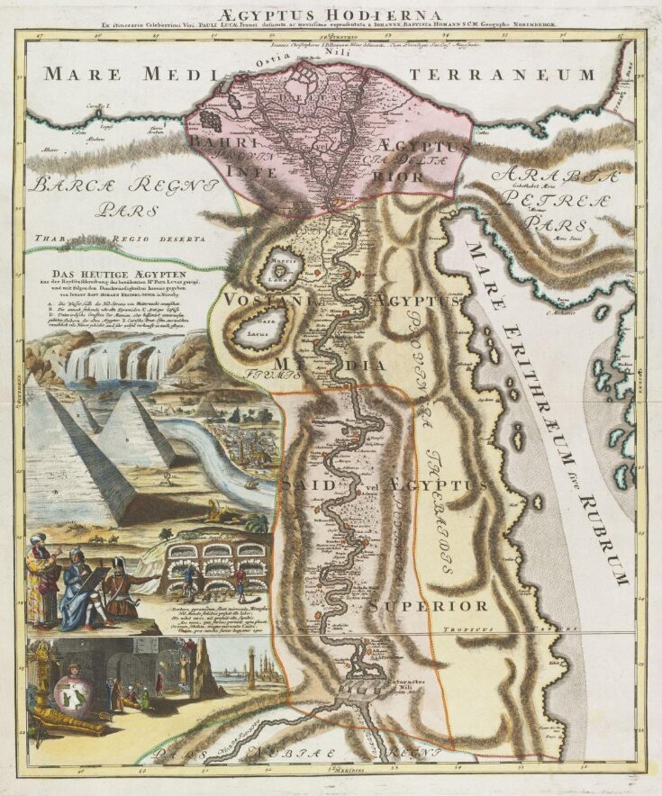
Etching, engraving, and stipple, coloured by hand, depicting an illustrated map of Egypt. Lettered in Latin with title, in German and Latin with key and descriptions, and 'Ex itinerario Celeberrimi Viri, Pauli Lucae Franci defumta, ac novissime repraesentata Iohanne Baptista Homann S.C.M. Geogapho Norimbergae. [From the itinerary of that most famous man, the Frenchman Paul Lucas, selected and newly printed by Johann Baptist Homann S.C.M. Geographer of Nuremberg.] Ioannes Christophorus I.B Homanni Filius delineavit. Cum Privilegio Sac.Caes. Majestatis'.
Object details
| Categories | |
| Object type | |
| Title | Aegypyus Hodierna (assigned by artist) |
| Materials and techniques | Etching, engraving, and stipple, coloured by hand |
| Brief description | Etching, engraving, and stipple entitled 'Aegypyus Hodierna', by Johann Christoph Homann, depicting an illustrated map of Egypt. German School, ca. 1719-1730. |
| Physical description | Etching, engraving, and stipple, coloured by hand, depicting an illustrated map of Egypt. Lettered in Latin with title, in German and Latin with key and descriptions, and 'Ex itinerario Celeberrimi Viri, Pauli Lucae Franci defumta, ac novissime repraesentata Iohanne Baptista Homann S.C.M. Geogapho Norimbergae. [From the itinerary of that most famous man, the Frenchman Paul Lucas, selected and newly printed by Johann Baptist Homann S.C.M. Geographer of Nuremberg.] Ioannes Christophorus I.B Homanni Filius delineavit. Cum Privilegio Sac.Caes. Majestatis'. |
| Dimensions |
|
| Credit line | The gift of Jillian Lees |
| Production | Paul Lucas (1664 1737), a French traveller in the Near East and Europe, on some occasions travelling officially for the King, published accounts of three major journeys. The course of the Nile from Cairo to the Cataracts in Homann's map corresponds to the map in Lucases, 'Voyage du Sieur Lucas au Levant, The Hague, 1709', first published in 1704, which includes a description of Upper Egypt. Homann's Nile delta corresponds to another map, made by Lucas in 1717, in vol.2, facing p.2, of 'Voyage du Sieur Paul Lucas, fait en M.DCCXIV', 3 vols., Rouen, 1719. |
| Subjects depicted | |
| Place depicted | |
| Collection | |
| Accession number | SP.323 |
About this object record
Explore the Collections contains over a million catalogue records, and over half a million images. It is a working database that includes information compiled over the life of the museum. Some of our records may contain offensive and discriminatory language, or reflect outdated ideas, practice and analysis. We are committed to addressing these issues, and to review and update our records accordingly.
You can write to us to suggest improvements to the record.
Suggest feedback
You can write to us to suggest improvements to the record.
Suggest feedback
| Record created | July 1, 2009 |
| Record URL |
Download as: JSONIIIF Manifest
