
Map of Batley
Design
1950s (made)
1950s (made)
| Artist/Maker | |
| Place of origin |
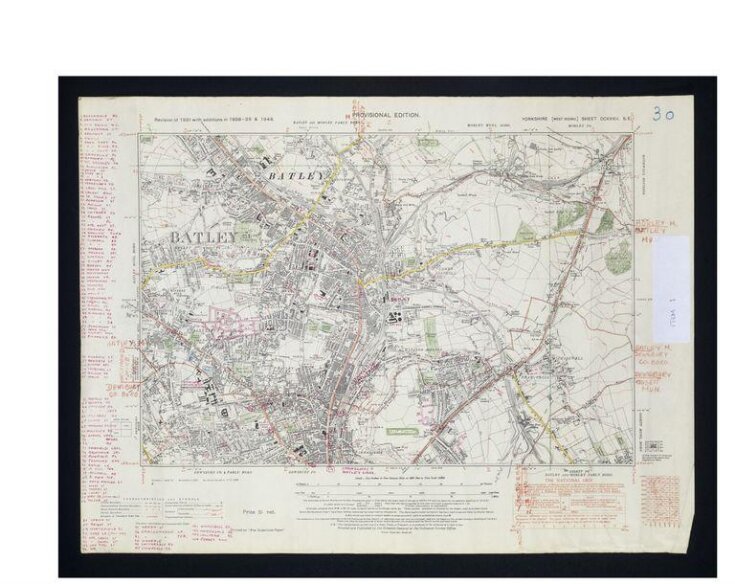
This is part of the original artwork for the Leeds and Bradford A–Z street atlas from the early 1950s. The publishers, the Geographers' A–Z Map Company, had established such a reputation with their famous London A-Z that they decided to extend their range of maps to other significant British cities.
Armed with this out-of-date Ordnance Survey map, staff at the Geographers' A–Z Map Company travelled to the area to see how suburban sprawl and wartime bombing had affected the local road layout. Their amendments can be seen here in red. The data was then taken back to the office and a new map drawn. Although maps are now revised using computers, the need for up-to-date information remains as critical as ever. The V&A has examples of original artwork from the Geographers' A–Z Map Company spanning 50 years in the company's history.
Armed with this out-of-date Ordnance Survey map, staff at the Geographers' A–Z Map Company travelled to the area to see how suburban sprawl and wartime bombing had affected the local road layout. Their amendments can be seen here in red. The data was then taken back to the office and a new map drawn. Although maps are now revised using computers, the need for up-to-date information remains as critical as ever. The V&A has examples of original artwork from the Geographers' A–Z Map Company spanning 50 years in the company's history.
Object details
| Categories | |
| Object type | |
| Title | Map of Batley (generic title) |
| Materials and techniques | Handcoloured print on paper |
| Brief description | A printed Ordnance Survey map of Batley, Yorkshire, handcoloured and annotated throughout in pen and pencil to show new roads. Prepared for reproduction and publication by the Geographers' A-Z Map Company, 1950s |
| Physical description | Printed map on paper handcoloured in green, red and yellow pencil and annotated extensively in red ink |
| Dimensions |
|
| Marks and inscriptions |
|
| Credit line | Given by Mrs Phyllis Pearsall MBE, FRGS |
| Subjects depicted | |
| Place depicted | |
| Summary | This is part of the original artwork for the Leeds and Bradford A–Z street atlas from the early 1950s. The publishers, the Geographers' A–Z Map Company, had established such a reputation with their famous London A-Z that they decided to extend their range of maps to other significant British cities. Armed with this out-of-date Ordnance Survey map, staff at the Geographers' A–Z Map Company travelled to the area to see how suburban sprawl and wartime bombing had affected the local road layout. Their amendments can be seen here in red. The data was then taken back to the office and a new map drawn. Although maps are now revised using computers, the need for up-to-date information remains as critical as ever. The V&A has examples of original artwork from the Geographers' A–Z Map Company spanning 50 years in the company's history. |
| Collection | |
| Accession number | E.861-2003 |
About this object record
Explore the Collections contains over a million catalogue records, and over half a million images. It is a working database that includes information compiled over the life of the museum. Some of our records may contain offensive and discriminatory language, or reflect outdated ideas, practice and analysis. We are committed to addressing these issues, and to review and update our records accordingly.
You can write to us to suggest improvements to the record.
Suggest feedback
You can write to us to suggest improvements to the record.
Suggest feedback
| Record created | September 24, 2004 |
| Record URL |
Download as: JSON
