
Artwork for London A-Z
Design
ca. 1960 (made)
ca. 1960 (made)
| Artist/Maker | |
| Place of origin |
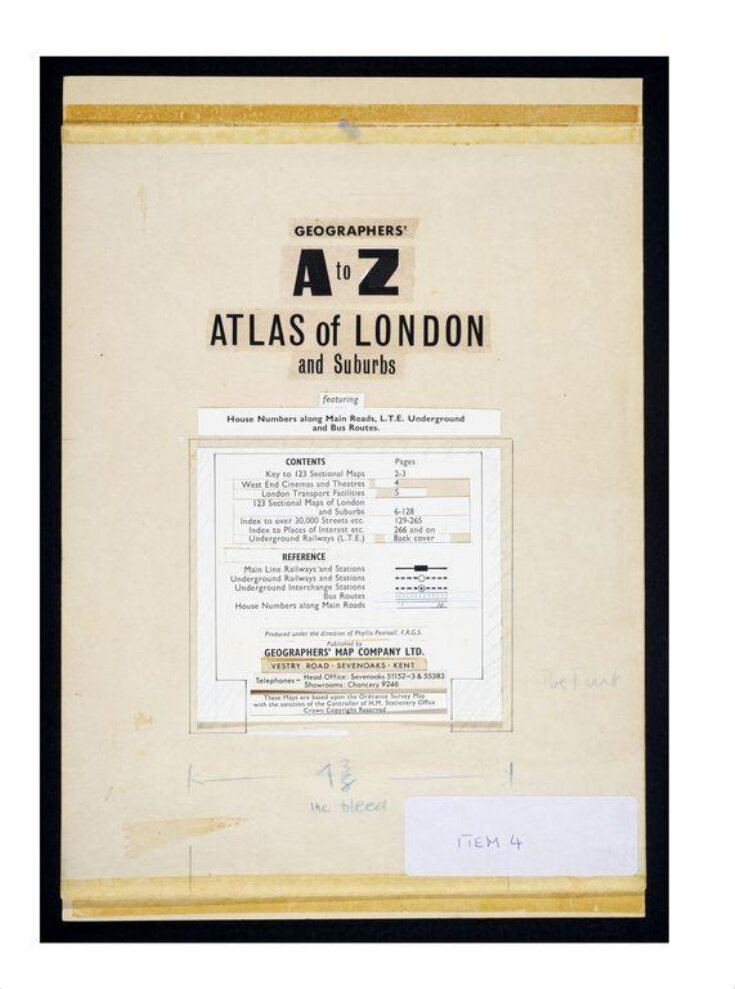
This is the original artwork for a cover of the London A–Z, the street atlas used by millions of London tourists and residents alike. It was made by the Geographers' A–Z Map Company in about 1960.
This stage of book production is known as a 'page patch-up'. The designer would take loose elements of text and images and assemble and reassemble them until he or she was completely satisfied. hey would then be stuck down and the finished page handed to the printer. This process is less common now that books are designed using computers. The V&A has examples of original artwork from the Geographers' A–Z Map Company spanning 50 years in the company's history.
This stage of book production is known as a 'page patch-up'. The designer would take loose elements of text and images and assemble and reassemble them until he or she was completely satisfied. hey would then be stuck down and the finished page handed to the printer. This process is less common now that books are designed using computers. The V&A has examples of original artwork from the Geographers' A–Z Map Company spanning 50 years in the company's history.
Object details
| Categories | |
| Object type | |
| Title | Artwork for London A-Z (generic title) |
| Materials and techniques | Printed paper on card |
| Brief description | The original artwork for the cover page of the London 'A-Z' in printed paper stuck on card, prepared for reproduction and publication by the Geographers' A-Z Map Company, about 1960 |
| Physical description | One sheet of card and one sheet of paper, once joined at the top but now separated. The sheet of paper is blank except for a pencil inscription. Cut-down strips of printed text are stuck down on the sheet of card and there are notes to the printer in blue pencil. |
| Dimensions |
|
| Marks and inscriptions |
|
| Credit line | Given by Mrs Phyllis Pearsall MBE, FRGS |
| Summary | This is the original artwork for a cover of the London A–Z, the street atlas used by millions of London tourists and residents alike. It was made by the Geographers' A–Z Map Company in about 1960. This stage of book production is known as a 'page patch-up'. The designer would take loose elements of text and images and assemble and reassemble them until he or she was completely satisfied. hey would then be stuck down and the finished page handed to the printer. This process is less common now that books are designed using computers. The V&A has examples of original artwork from the Geographers' A–Z Map Company spanning 50 years in the company's history. |
| Collection | |
| Accession number | E.859-2003 |
About this object record
Explore the Collections contains over a million catalogue records, and over half a million images. It is a working database that includes information compiled over the life of the museum. Some of our records may contain offensive and discriminatory language, or reflect outdated ideas, practice and analysis. We are committed to addressing these issues, and to review and update our records accordingly.
You can write to us to suggest improvements to the record.
Suggest feedback
You can write to us to suggest improvements to the record.
Suggest feedback
| Record created | September 24, 2004 |
| Record URL |
Download as: JSON
