
Londinum Antiqua
Print
1737
1737
| Artist/Maker | |
| Place of origin |
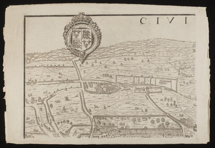
This is one sheet of eight that come together to make a map of London. The map is a copy, engraved by George Vertue in 1737, of a famous map of London from the 16th Century supposedly by Ralph Agas a known land surveyor. The dating of the original map to 1560 and the attribution to Agas are now both questioned. The map shows the development of London from two separate cities of London and Westminster. It portrays clearly the division of the power of the court in Westminster and the institutions of the City of London itself bordered by Saint Paul's and the Tower of London. This map shows how the expanding city was beginning to breach its old medieval walls. The map is also full of charming incidental detail of everyday life: the swans bobbing on the river, women laying linen out to dry, farmers hunting, ship-building and driving cattle into the river. The decision by Vertue to engrave and publish this old map of London in the 18th century is indicative of their awareness of and interest in history. However, there are doubts as to the honesty with which Vertue re-engraved the older map. It has been suggested that Vertue doctored the map whilst copying it in order to make it appear older than it actually was in order to fool his antiquary contemporaries.
Object details
| Categories | |
| Object type | |
| Title | Londinum Antiqua |
| Materials and techniques | |
| Brief description | One sheet of eight that come together to make a map of London. Civitas Londinum Anno Domini Circiter MDLX. Drawn by Radulphus Aggas. Re-engraved by George Vertue, 1737. |
| Physical description | Part of a map of London. The map is drawn in a plan with elevations of houses, churches and other buildings. The hills in the distance are drawn in perspective whilst the actual city of London itself is a plan. Street names are included on the map. There are many incidental details of human activity and daily life. Boats and swans bob about on the river, people hunt and animals graze on the land. A key to the map is included as are the coat of arms for the royal family and the city of London. |
| Dimensions |
|
| Marks and inscriptions | This plan shows the ancient extent of the famous cities of London and Westminster as it was near the beginning of the reign of Queen Elisabeth these plates for their great scarcity are re-ingraved to oblige the curious and to hand to posterity this old prospect whereby at one vein may be seen how much was built of this populous city parts ajacent at that time.
Radulphus Aggas in his Oxonicae Antiqua published A.D. 1578 says near ten years past the author made a doubt whether to print or lay this work aside until he first had London plotted out.
Vertue soc Antiq. Lond. Excudit 1737
(Also contains a key to the map with reference to bridges, churches, city gates, docks, cock pits and important houses and streets.) |
| Subjects depicted | |
| Place depicted | |
| Summary | This is one sheet of eight that come together to make a map of London. The map is a copy, engraved by George Vertue in 1737, of a famous map of London from the 16th Century supposedly by Ralph Agas a known land surveyor. The dating of the original map to 1560 and the attribution to Agas are now both questioned. The map shows the development of London from two separate cities of London and Westminster. It portrays clearly the division of the power of the court in Westminster and the institutions of the City of London itself bordered by Saint Paul's and the Tower of London. This map shows how the expanding city was beginning to breach its old medieval walls. The map is also full of charming incidental detail of everyday life: the swans bobbing on the river, women laying linen out to dry, farmers hunting, ship-building and driving cattle into the river. The decision by Vertue to engrave and publish this old map of London in the 18th century is indicative of their awareness of and interest in history. However, there are doubts as to the honesty with which Vertue re-engraved the older map. It has been suggested that Vertue doctored the map whilst copying it in order to make it appear older than it actually was in order to fool his antiquary contemporaries. |
| Associated objects | |
| Bibliographic reference | To Know One's Own: Estate Surveying and the Representation of the Land in Early Modern England, Andrew McRae, Huntington Library Quarterly, Vol. 56, No. 4 (Autumn, 1993), pp. 333-357 |
| Collection | |
| Accession number | 29190:4 |
About this object record
Explore the Collections contains over a million catalogue records, and over half a million images. It is a working database that includes information compiled over the life of the museum. Some of our records may contain offensive and discriminatory language, or reflect outdated ideas, practice and analysis. We are committed to addressing these issues, and to review and update our records accordingly.
You can write to us to suggest improvements to the record.
Suggest feedback
You can write to us to suggest improvements to the record.
Suggest feedback
| Record created | June 30, 2009 |
| Record URL |
Download as: JSONIIIF Manifest
