
Sampler
1797 (dated)
| Artist/Maker | |
| Place of origin |
Object Type
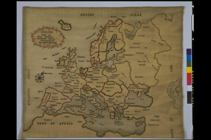
Map samplers like this were exercises in embroidery carried out by young girls, intended to be framed like pictures and displayed. Their popularity is partly explained by the dual function they served, of demonstrating both the pupil's needlework skills and her geographical knowledge.
Materials & Making
The earlier map samplers have hand-drawn or traced outlines. They were prepared by the teacher or governess in many cases, and that may have happened here. We do not know how old Elizabeth Hawkins was when she embroidered the map, but the slightly haphazard spacing of its place names suggests an inexperienced hand, and she probably located these herself.
Subjects Depicted
The map of Europe embroidered here was one of the most popular choices, but the range of possibilities was wide. A pupil might choose to depict as local an area as the field layout of a nearby estate, or her country, its continent, the two hemispheres of the globe or even the solar system. Such complex maps as the two hemispheres were almost always undertaken on printed grounds, which were effectively sampler kits, although generally left with bare borders to allow for some personalisation.
Object details
| Categories | |
| Object type | |
| Materials and techniques | Embroidered wool in silks, backed with paper |
| Brief description | Woollen sampler embroidered with coloured silk, made by Elizabeth Hawkins, Plymouth, England, dated 1797 |
| Physical description | Woollen sampler embroidered with coloured silk in cross and chain stitches. With a map of Europe and each country is outlined in coloured silks. The map extends from the Frozen Ocean in the north, the Caspian Sea in the east, the North African coast in the south, and the West Coast of Europe in the west. In the top left corner is a small cartouche which is inscribed. The sampler is backed with paper, parts of which have been painted blue to indicate sea. Nailed to a wooden backboard. |
| Dimensions |
|
| Marks and inscriptions | 'EUROPE / DONE AT / MISS POWELLS / BOARDING SCHOOL / PLYMOUTH BY / ELIZABETH HAWKINS / 1797' (Embroidered in the top left corner in a small cartouche) |
| Gallery label | British Galleries:
The making of map samplers was encouraged as an educational exercise for young girls from about 1770 to 1820. Such work incorporated lessons in geography as well as embroidery. In the earlier examples, as in this case, the outline was drawn first and then embroidered over. Later on, they became so popular that special map prints were produced ready to embroider.(27/03/2003) |
| Credit line | Given by Mrs. Amy P. Rean |
| Production | Made at Miss Powell's Boarding School, Plymouth. |
| Subject depicted | |
| Place depicted | |
| Summary | Object Type Map samplers like this were exercises in embroidery carried out by young girls, intended to be framed like pictures and displayed. Their popularity is partly explained by the dual function they served, of demonstrating both the pupil's needlework skills and her geographical knowledge. Materials & Making The earlier map samplers have hand-drawn or traced outlines. They were prepared by the teacher or governess in many cases, and that may have happened here. We do not know how old Elizabeth Hawkins was when she embroidered the map, but the slightly haphazard spacing of its place names suggests an inexperienced hand, and she probably located these herself. Subjects Depicted The map of Europe embroidered here was one of the most popular choices, but the range of possibilities was wide. A pupil might choose to depict as local an area as the field layout of a nearby estate, or her country, its continent, the two hemispheres of the globe or even the solar system. Such complex maps as the two hemispheres were almost always undertaken on printed grounds, which were effectively sampler kits, although generally left with bare borders to allow for some personalisation. |
| Bibliographic reference | Browne, Clare and Jennifer Wearden, eds. Samplers from the Victoria and Albert Museum. London : V&A Publications, 1999. 144 p., ill. ISBN 1851773096. |
| Collection | |
| Accession number | T.165-1959 |
About this object record
Explore the Collections contains over a million catalogue records, and over half a million images. It is a working database that includes information compiled over the life of the museum. Some of our records may contain offensive and discriminatory language, or reflect outdated ideas, practice and analysis. We are committed to addressing these issues, and to review and update our records accordingly.
You can write to us to suggest improvements to the record.
Suggest feedback
You can write to us to suggest improvements to the record.
Suggest feedback
| Record created | November 19, 2002 |
| Record URL |
Download as: JSONIIIF Manifest
