
The Travellers of Europe, with Improvements and Additions
Board Game
01/12/1852 (published)
01/12/1852 (published)
| Artist/Maker | |
| Place of origin |
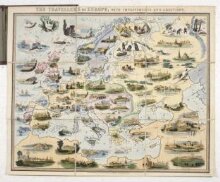
Five players take the parts of The Travellers, who are from different nations, Austria, Sweden, Russia, Prussia and England. They must make their way to their respective capital cities each starting from a different city in Africa, or on the shore of the Mediterranean Sea. They play with a teetotum or spinner with four sides marked N,S,E,W representing the directions they must move in. The game was first published in 1842 and the rules booklet that goes with this game is dated 1849, making it earlier than the game itself.
Object details
| Categories | |
| Object type | |
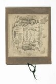
| Parts | This object consists of 2 parts.
|
| Title | The Travellers of Europe, with Improvements and Additions (manufacturer's title) |
| Materials and techniques | Hand-coloured lithographed paper |
| Brief description | Hand coloured geographical race game, The Travellers of Europe, published in England by William Spooner in 1852 |
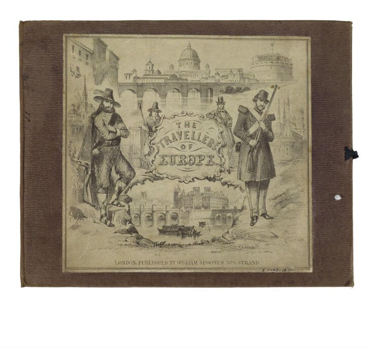
| Physical description | RACE GAME, GEOGRAPHICAL - EUROPE Design: lithograph, coloured by hand; 9 sections mounted on linen and showing a map of Europe with topographical scenes. Printer L'Enfant, Printer, 12 Rathbone Street. No. of squares: 10 sections Squares illustrated: overall Squares titled: in booklet Subject of starting square: Lapland Subject of ending square: Greece playing sheet folds into cloth covered boards with ribbon ties; bearing a label with a lithographed pictorial label playing sheet shows views of various cities in Europe, North Africa and the Middle East, with the lines of latitude and longitude. Equipment required: travellers/markers lettered A to E; teetotum with four sides marked N,E,S,W representing directions |
| Dimensions |
|
| Marks and inscriptions | L'Enfant, Printer, 12 Rathbone Street (on lower edge; printed) |
| Object history | this is a later edition of the game entitled `The Travellers: or, a Tour Through Europe', issued December 1st 1842 (Table Games of Georgian & Victorian Times, p. 17). Inscribed in ink inside the front cover `Mary Crewdson Cowherd from her Aunt Henry Fox Octr. 28, 1854. |
| Historical context | Rewards: paid from the pool, following directions listed on the game itself Forfeits: paid into the pool following directions listed on the game itself No. of Players: 5 Rules: PREFACE TO THE BOOKLET OF RULES. The compiler of `The Travellers', who has on many occasions successfully catered for the entertainment of youth, has in the present game, aimed at the higher object of blending instruction with amusement; and while he has attempted to impart the elements of geographical knowledge to very young learners , he has not neglected to make the medium as pleasant and amusing as that of any one of his former popular games. The Study of Geography, in itself so interesting, when pursued through the formal details of a chart,, may not at first offer an attraction to the youthful student; but by means of an emulative game, in which the distances and positions of the various countries and capitals are geographically defined, and in which the leading cities of Europe are illustrated by correct representations, the publisher has thought to stimulate the young inquirer to that thirst after knowledge, which may be perfected in maturer years. The pictorial illustrations of cities are derived from the most recent views on approved authorities, as the Whale Fishery in the Northern Ocean, and the Giant's Causeway in Ireland; or some peculiar custom is portrayed, as sledge travelling in Russia, and the perilous sports of the remote inhabitants of Finland and of Siberia. Little, it is presumed, need be said in favour of a mode of information at once so pleasing and so exact; or of an amusement which will leave on the youthful mind many of the solid advantages of a more regular instruction. The publisher, therefore, presents this little game which equal confidence both to parents and to children, in the full assurance that to the former it will afford all the satisfaction, and to the latter all the amusement, which either he or they can desire. To those little wayfarers who, by so many various routes, seek the object of the heart's constant affections - Home - he recommends not only the patience and perseverance of more matured travellers, but that as they meet or cross each others' path on this extended stage of travel, they should cultivate that kindness and good humour which sweeten the path of life - to the child as well as to the man - in the city and in the desert, as well as by their own cheerful and contented firesides. Game: The Travellers who are of different nations, having journeyed in company through various parts of the world, agree on arriving at Alexandria to return home to the capitals of their respective countries, by embarking each from some different city in Africa, or on the shore of the Mediterranean Sea. The Austrian (distinguished by the mark A) is to start from Jerusalem; The Russian (marked B) from Cairo; the Swede (marked C) from Alexandria; the Prussian (marked D) from Tripoli; and the Englishman (marked E) from Morocco. Close to, or upon, these cities, the points of starting are marked S, and each traveller places his mark or counter on the part of the city from which has to commence his journey. Their journeys are to be pursued by the turning up of the totum, which is marked with the letters N, E, S, W representing north, east, south and west; and each traveller is to move along the lines of the pictorial map from cross to cross of the squares as may be determined by the totum. If the totum turns up: N: the player moves north or upwards to the next corner, or crossing of the lines, in a direct road above him; if E: he moves to the next corner, or crossing of the lines, on the right or east; if S: he moves to the corner immediately below or south; if W: he is to move to the next corner to his left or west. All these movements must be along the lines; and each time not further than the first crossing of the lines. It must be well understood that N indicates North or Upward, E - East or right, S - South or downward, W - West or left. The destination of each traveller is shewn by a circle having the letter of the mark of the player. Rules 1. Draw lots to determine who shall play first, second, third etc. 2. Each player is to put three counters into the pool on commencing the game. 3. When a player is directed to move to a crossing or angle occupied by another player; they are to change places with each other. 4. When a player is so near the margin of the map he can not find an angle or cross to move when directed, he will wait till his next turn to play. 5. Forfeits are to be paid to, and the prizes taken from the pool, according as the players reach the places where they are named. 6. Whoever arrives at, or passes over, any part of the capital of a kingdom which is marked and fails to name the country of which it is the capital, is to pay two counters into the pool. , and the first player in each game is to hold the book and to enforce the fines at the time, or to pay one counter himself to the pool for every neglect. 7. When every player has travelled to the extreme part of the North, so as to come on the circle at the top of the map which marks the 'Arctic Ocean' he may take his mark to within two moves in any direction of his own capital. (This rule is made in order to abridge the duration of the game and to give variety and it may either be adopted or not, as the players may determine when they commence the game). 8. The traveller who first reaches the capital of his country by passing along the lines that has the circle corresponding with his mark, wins the game and takes the contents of the pool. Fines and rewards are indicated on the playing sheet at the intersections of various lines of latitude and longitude. GEOGRAPHICAL DESCRIPTION The Earth or Globe, consisting of land and water,-the former of which comprehends four grand divisions, called Europe,. Asia, Africa and America,-may be represented either in the whole or in part, by geographical charts or maps. The Division our pictorial map attempts to illustrate, is Europe - the smallest but the most civilized of the four quarters of the world. It is bounded on the north by the Arctic Ocean; on the west by the Atlantic Ocean; on the south by the Mediterranean Sea and the Black Sea; and on the east by Asia. The following countries comprise the various Divisions of Europe:- LAPLAND-divided into Swedish and Russian Lapland SWEDEN and NORWAY - DENMARK RUSSIA in EUROPE-POLAND-FINLAND GERMANY-consisting of the Empire of Austria, the Kingdom of Prussia, and the States of Germany HOLLAND-BELGIUM GREAT BRITAIN-comprehending England, Wales and Scotland IRELAND FRANCE-SWITZERLAND-ITALY SPAIN-PORTUGAL TURKEY in EUROPE-GREECE 1. LAPLAND-Part of which belongs to Russia and part to Sweden, is the most northern country in Europe, and is divided into North, South and East Lapland. The climate is very cold, and the country mountainous, with immense forests of fir, and tracts of land covered with moss. The natives are in a very rude state of civilization; and the whole amount of the population is supposed not to exceed 60,000. In the northern part of Lapland the differences in the length of day and night are greater than in any other part of the inhabited world. The longest day in summer is about eight weeks, during which period the sun never sets; and in winter the longest night continues for a similar period. Rules placement: booklet, published by Spooner 1849 |
| Production | Printed by L'Enfant, 12 Rathbone Street |
| Place depicted | |
| Summary | Five players take the parts of The Travellers, who are from different nations, Austria, Sweden, Russia, Prussia and England. They must make their way to their respective capital cities each starting from a different city in Africa, or on the shore of the Mediterranean Sea. They play with a teetotum or spinner with four sides marked N,S,E,W representing the directions they must move in. The game was first published in 1842 and the rules booklet that goes with this game is dated 1849, making it earlier than the game itself. |
| Bibliographic references |
|
| Collection | |
| Accession number | E.1788&A-1954 |
About this object record
Explore the Collections contains over a million catalogue records, and over half a million images. It is a working database that includes information compiled over the life of the museum. Some of our records may contain offensive and discriminatory language, or reflect outdated ideas, practice and analysis. We are committed to addressing these issues, and to review and update our records accordingly.
You can write to us to suggest improvements to the record.
Suggest feedback
You can write to us to suggest improvements to the record.
Suggest feedback
| Record created | March 4, 2000 |
| Record URL |
Download as: JSONIIIF Manifest
