
This object, or the text that describes it, is deemed offensive and discriminatory. We are committed to improving our records, and work is ongoing.
A Plan of the Town of St Jago de la Vega, in the Island of Jamaica
Print
1786 (printed and published)
1786 (printed and published)
| Artist/Maker | |
| Place of origin |
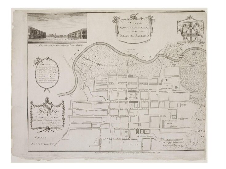
This map from 1786 shows the street plan of the town of St Jago de la Vega in Jamaica. Later named Spanish Town, St Jago was once the English capital of Jamaica. This map, dedicated to Sir John Dalling by John Pitcairne, indicates the ownership of specific areas and has a numbered key which shows the location of the main public buildings. An area labelled ‘The Negroe Market’ indicates the town’s role in the slave trade at this time.
Object details
| Categories | |
| Object type | |
| Title | A Plan of the Town of St Jago de la Vega, in the Island of Jamaica (assigned by artist) |
| Materials and techniques | Engraving on paper |
| Brief description | Simpson, 'A Plan of the Town St Jago de la Vega, in the Island of Jamaica', engraving; London, 1786 |
| Physical description | A map of a town by the sea, which has been cut at the right hand side. It shows the principal roads, the port and areas of open ground. Top left is a coat of arms, top right an image of the King's house and public offices, and lower a right a dedication. |
| Dimensions |
|
| Marks and inscriptions |
|
| Gallery label | This map, dedicated to Sir John Dalling by John Pitcairne, indicates the ownership of specific areas and shows the location of the main public buildings. An area labelled 'The Negroe Market' indicates the town's role in the slave trade at this time.(2007) |
| Object history | NB: The term "negro" was used historically to describe people of black African heritage but, since the 1960s, has fallen from usage and, increasingly, is considered offensive. The term is repeated here in its original historical context. |
| Subjects depicted | |
| Place depicted | |
| Summary | This map from 1786 shows the street plan of the town of St Jago de la Vega in Jamaica. Later named Spanish Town, St Jago was once the English capital of Jamaica. This map, dedicated to Sir John Dalling by John Pitcairne, indicates the ownership of specific areas and has a numbered key which shows the location of the main public buildings. An area labelled ‘The Negroe Market’ indicates the town’s role in the slave trade at this time. |
| Collection | |
| Accession number | E.71-1940 |
About this object record
Explore the Collections contains over a million catalogue records, and over half a million images. It is a working database that includes information compiled over the life of the museum. Some of our records may contain offensive and discriminatory language, or reflect outdated ideas, practice and analysis. We are committed to addressing these issues, and to review and update our records accordingly.
You can write to us to suggest improvements to the record.
Suggest feedback
You can write to us to suggest improvements to the record.
Suggest feedback
| Record created | July 18, 2007 |
| Record URL |
Download as: JSONIIIF Manifest
