
Similands
Print
2006 (made)
2006 (made)
| Artist/Maker | |
| Place of origin |
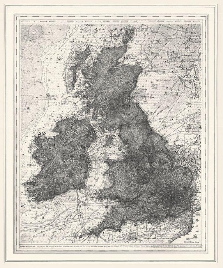
This print is based on a drawing made in 2004/5. Much of Walter’s recent work has explored his fascination with maps – both as products of specific cultures, and as the site of signs and symbols. He sees mapping itself as an obsessive activity and this is reflected in the dense working of the pattern of motifs here. Similands is designed to look like a reproduction of a map of the British Isles from the 16th or 17th century, but all of the imagery is specific to contemporary Britain and is a satirical comment on the commercialisation and homogenisation of our culture.
Britain is presented here as one dense suburb, peppered with logos for tourist attractions, fast-food outlets, and snippets of local folk-lore. Signs for airports, car parks, McDonalds, toxic waste and hazardous substances are jumbled together with tourist information signs, graffiti, road-signs, identikit box-like Barrett homes, and the occasional tree represented by the conventional map symbols for deciduous or evergreen species.
In a statement which accompanied his exhibition of map drawings ‘Be Aware of Everything’ at the Drawing Gallery, London, in 2005, Walter described his thinking as follows: “In a time when our relationship with the natural land is ever decreasing, references to Romanticism must change in accordance with the present codes, practices and influences found in heavily humanised environments. This increasing ‘distance’ and the disenfranchisement of a lost wilderness serves as an underlying drive behind the work. With domesticated, suburban, plastic and supermarket-ridden environments, technology and information provide the new wilderness, unavoidable within the realms of a contemporary sublime.”
Object details
| Category | |
| Object type | |
| Title | Similands (assigned by artist) |
| Materials and techniques | Digital inkjet print on paper |
| Brief description | 'Similands', map of the British Isles, inkjet print by Stephen Walter; United Kingdom, 2006 |
| Physical description | A map of the British Isles densely worked with signs, symbols, logos and brand names. |
| Dimensions |
|
| Copy number | 1/50 |
| Gallery label | This print imitates 16th and 17th century maps, but here Britain is presented as a single dense suburb peppered with logos and signs, graffiti and box-like buildings, with odd green spaces indicated by the conventional map symbols for trees. Walter intends it as a satirical comment on the commercialisation and homogenisation of our culture.(2007) |
| Credit line | Purchased through the Julie and Robert Breckman Print Fund |
| Object history | Purchased through the Julie and Robert Breckman Print Fund |
| Subjects depicted | |
| Summary | This print is based on a drawing made in 2004/5. Much of Walter’s recent work has explored his fascination with maps – both as products of specific cultures, and as the site of signs and symbols. He sees mapping itself as an obsessive activity and this is reflected in the dense working of the pattern of motifs here. Similands is designed to look like a reproduction of a map of the British Isles from the 16th or 17th century, but all of the imagery is specific to contemporary Britain and is a satirical comment on the commercialisation and homogenisation of our culture. Britain is presented here as one dense suburb, peppered with logos for tourist attractions, fast-food outlets, and snippets of local folk-lore. Signs for airports, car parks, McDonalds, toxic waste and hazardous substances are jumbled together with tourist information signs, graffiti, road-signs, identikit box-like Barrett homes, and the occasional tree represented by the conventional map symbols for deciduous or evergreen species. In a statement which accompanied his exhibition of map drawings ‘Be Aware of Everything’ at the Drawing Gallery, London, in 2005, Walter described his thinking as follows: “In a time when our relationship with the natural land is ever decreasing, references to Romanticism must change in accordance with the present codes, practices and influences found in heavily humanised environments. This increasing ‘distance’ and the disenfranchisement of a lost wilderness serves as an underlying drive behind the work. With domesticated, suburban, plastic and supermarket-ridden environments, technology and information provide the new wilderness, unavoidable within the realms of a contemporary sublime.” |
| Collection | |
| Accession number | E.55-2007 |
About this object record
Explore the Collections contains over a million catalogue records, and over half a million images. It is a working database that includes information compiled over the life of the museum. Some of our records may contain offensive and discriminatory language, or reflect outdated ideas, practice and analysis. We are committed to addressing these issues, and to review and update our records accordingly.
You can write to us to suggest improvements to the record.
Suggest feedback
You can write to us to suggest improvements to the record.
Suggest feedback
| Record created | March 23, 2007 |
| Record URL |
Download as: JSON
