
A Map of a Farm and 12 Pieces of Land thereto belonging; lying in the Parish of Reculver in the county of Kent: Part of the Estate of Henry Waddell, Gent
Watercolour
1730 (made)
1730 (made)
| Artist/Maker | |
| Place of origin |
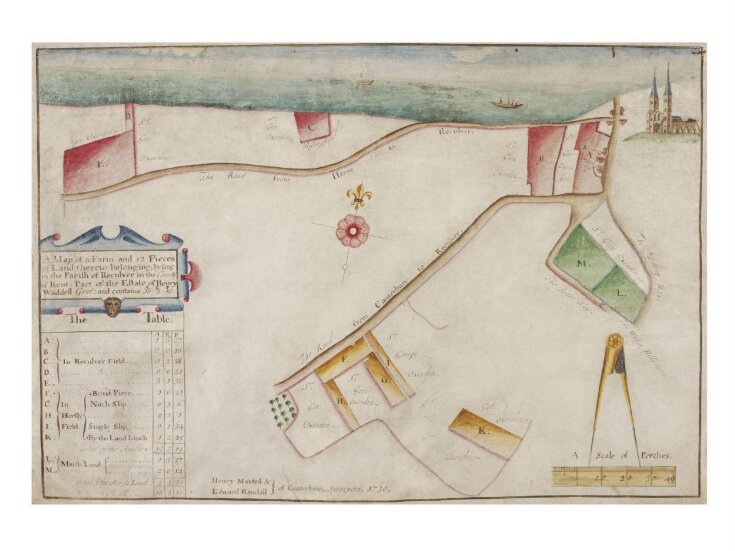
Maps have had an important function as legal documents. This is an estate map drawn up by Henry Maxted recording a farm and adjacent land by the sea at Reculver in Kent. It was made in 1730 and it is drawn on vellum, a material often used for documents because of its durability. This map was clearly made to record land ownership and would have been useful for management of the estate. For example the draughtsman has added a coded key to distinguish different types of ground, such as the green areas labelled M and L which the key records as Marsh Land. The map mixes the diagrammatic features of conventional maps with fanciful pictorial elements. The pair of compasses shown at the lower right corner indicates the scale of map. The scale is given in perches; a perch was a linear measure (now defunct) equal to 5.50 yards (5.03 metres).
Delve deeper
Discover more about this object

Object details
| Categories | |
| Object type | |
| Title | A Map of a Farm and 12 Pieces of Land thereto belonging; lying in the Parish of Reculver in the county of Kent: Part of the Estate of Henry Waddell, Gent (assigned by artist) |
| Materials and techniques | Pen and ink and watercolour on vellum |
| Brief description | 'Map of a Farm etc in Reculver, Kent, the estate of Henry Waddell', watercolour by Henry Maxted; Kent, 1730 |
| Physical description | A crudely drawn map showing fields and lands comprising Henry Waddell's estate. Drawn in watercolour on vellum. |
| Dimensions |
|
| Marks and inscriptions |
|
| Gallery label | Maps such as this were legal documents, recording land ownership and marking boundaries, roads and rights of way. They were also useful for the purposes of estate management. This map mixes digrammatic features with fanciful pictorial elements, and is colour-coded to distinguish different types of ground.(2007) |
| Credit line | Given by Lady Capel Cure |
| Subjects depicted | |
| Place depicted | |
| Summary | Maps have had an important function as legal documents. This is an estate map drawn up by Henry Maxted recording a farm and adjacent land by the sea at Reculver in Kent. It was made in 1730 and it is drawn on vellum, a material often used for documents because of its durability. This map was clearly made to record land ownership and would have been useful for management of the estate. For example the draughtsman has added a coded key to distinguish different types of ground, such as the green areas labelled M and L which the key records as Marsh Land. The map mixes the diagrammatic features of conventional maps with fanciful pictorial elements. The pair of compasses shown at the lower right corner indicates the scale of map. The scale is given in perches; a perch was a linear measure (now defunct) equal to 5.50 yards (5.03 metres). |
| Collection | |
| Accession number | E.3495-1931 |
About this object record
Explore the Collections contains over a million catalogue records, and over half a million images. It is a working database that includes information compiled over the life of the museum. Some of our records may contain offensive and discriminatory language, or reflect outdated ideas, practice and analysis. We are committed to addressing these issues, and to review and update our records accordingly.
You can write to us to suggest improvements to the record.
Suggest feedback
You can write to us to suggest improvements to the record.
Suggest feedback
| Record created | March 20, 2007 |
| Record URL |
Download as: JSONIIIF Manifest
